Streets throughout Somerville to be designated “Neighborways” with reduced vehicle speeds
(Somerville Wire) – The City is currently planning a broad new system of bicycle routes throughout Somerville. The preliminary plans, which are being vetted in small pop-ups around the city this spring and summer, would add more separated bike lanes and also improve protection for bicyclists on big and small streets throughout the city.
The Office of Strategic Planning and Community Development hopes to begin creating the new infrastructure next spring.
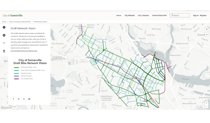
The Mobility Division of OSPCD held a virtual meeting last Thursday, June 23 to present a draft version of the Bicycle Network Map, a key part of the new plan.
The meeting was led by Viola Augustin, senior planner with the Mobility Division. According to Augustin, the goals of the Bicycle Network Plan are based on strategic plans already approved by the City, such as Somervision 2040, the Complete Streets Ordinance, Vision Zero Somerville (Safe Streets for All), and Somerville Climate Forward.
She said the Bicycle Network Plan is intended to: reduce miles traveled by car and prioritize walking, biking, and mass transit; prioritize safety for vulnerable road users of all ages and abilities; incorporate bicycle, pedestrian, and transit facilities in street projects; and reduce emissions from personal vehicles, which make up 98 percent of all emissions from transportation.
“The Network Plan will support our goal to provide equitable access to safe and comfortable infrastructure for users of all ages and abilities to ride a bike to anywhere in the city,” Augustin said. She added that the planners hope to entice more people “to choose the bike as their main transportation mode around the city.”
Kate White, outreach coordinator for the Mobility Division, explained that “community engagement” to garner input about the project began last year. They launched their outreach with a “bike talk” last June, followed by a series of “handlebar survey rides” last fall, “which is where we go out on group rides and assess segments of streets on elements like safety, design, and amenities,” White said.
The Mobility team then hosted a virtual public meeting last December to hear input on “key destinations and desires for street designs,” White said. They also conducted an online survey, which garnered over 330 responses, on safety issues, routes and destinations, and other aspects of the plan.
In recent months, they have attended community events and pop-ups “to promote the plan development, create awareness, and gather feedback,” she said. They also placed informational posters in libraries and other community locations, hung handlebar tags on bicycles, and publicized the initiative through City email and social media communications.
The survey respondents were most likely to want the City to “install more bike lanes and paths physically separated from vehicles, create a more connected bike network, create smoother road and bike lane surfaces, and improve visibility at intersections by restricting parking close to them,” Augustin said.
“Some of the roads people feel unsafe traveling on were Highland Avenue, Elm Street, Holland Street, Somerville Avenue, and Washington Street. Some of the intersections people feel unsafe traveling through were McGrath Highway and Washington Street, Davis Square, Teele Square, and Union Square,” she said.
The goal of the new network, Augustin said, is to improve on the existing conditions by designating more bike lanes, connecting gaps in the current network, and providing a guide for future developments in the city.
Somerville’s existing bike network comprises 22.6 miles. That includes 12.7 miles of regular bike lanes (painted on the ground but not physically separated from other traffic), 4.46 miles of protected (separated) bike lanes, and another 5.5 miles of shared-use, off-road paths for bikes and pedestrians such as the Community Path.
The new network will add protected bike lanes on more streets where there’s a need for greater separation. “These are our larger streets with higher volume and higher speed,” said Augustin.
Implementation options include a one-way bicycle lane on each side of the road, a two-way bicycle lane on one side of the road, or pairing two parallel streets with one-way bike lanes on each street. Augustin cited Willow and Cedar streets as an example of a potential pairing.
“When possible, we will maintain one side of parking” on streets with new bike lanes, she said.
The Network Plan will also identify many streets as “Neighborways” or “Shared Streets.” These are lower-volume residential streets where vehicles and bicycles share the road.
The objectives for these two designations of streets are to reduce volume to less than 1,000 cars per day, and to reduce speed to less than 20 mph.
“We will design those so that cars will have to be slow, and we will design them so that they’re not good candidates for through streets,” she said. “As most of you know, we already have Neighborways designations on the street, and they definitely have to have the next iteration of design to really make sure that they’re not used by cars as through streets, and therefore have less cars and less speed on them.”
For example, she said, they are considering making Bow Street in Union Square a Shared Street, where cars, bicyclists, and pedestrians will all share more of the roadway. “Those will have to be thoughtfully designed to provide clear pedestrian zones,” she explained, “and make sure that cars are as slow as possible.”
Streets were selected for new bicycle facilities “based on some of the feedback we’ve heard [from the community], and also research we’ve done with other plans. And all of it, we clearly have the equity lens through it, that we’re really trying to provide equal access for everybody,” Augustin said. “We want to make sure that, throughout the city, every resident has access to this network.”
They also had to take account of Somerville’s many hills, “so if we have choices, we chose the less hilly route, and possibly routes or streets that are already well covered with trees and provide shade,” she said.
White said the new Neighborways would require “a tremendous amount of traffic calming, to make sure that street feels safe.” Possible calming methods include speed humps, narrowing of the street, or adding more greenery.
Asked by a community member at the meeting whether all the bikeways crossing the Cambridge border will connect between the two cities, White said, “We’ve really tried to look closely at Cambridge’s [bike infrastructure], because we recognize the importance of intra-city connections.”
Another audience member said cargo bikes are becoming more popular in Europe, although they are more expensive and wider than regular bikes.
Mike Lydon of Street Plans, an urban design firm based in New York and Miami—which was hired by the city to help create the Bicycle Network Plan—expressed enthusiasm about cargo bikes.
“Here in New York City, where I’m based, we’re seeing now a movement towards UPS and other delivery providers moving towards a cargo bike model. Even delivery from grocery stores like Whole Foods using cargo bikes. So it’s a huge growth opportunity for cycling and to replace those car trips with bike trips,” he said.
Lydon added that cargo bikes do have the drawback that they’re wider and need more space than regular bikes. “So there are some good problems to solve once you get more people on cargo bikes. That’s for sure.”
One participant asked how Somerville compares with Cambridge, which has seen significant controversy over its construction of many miles of bike lanes in the past few years.
“We’re aware of what’s going on in Cambridge,” said Augustin. “We don’t want to suggest things that will be really hard and controversial to do. It’s always, you know, what we all want and what we believe is possible, and then the reality of residents on the street.”
“So we’re trying to be mindful,” she added, “preparing and learning from Cambridge, and making sure that our iteration is a little less painful.”
The Bike Map will be presented to the public at several events in the coming weeks. “We will take the next month to get all the feedback we can on this proposed network,” Augustin said.
Four pop-ups are scheduled for July, where the Mobility Team will have tables with plans and the draft map: July 12 from 4:30-6:30 p.m. on the Community Path, at the Cedar Street Crossing; July 16 from 11 a.m. to 2 p.m. at the ArtBeat Festival; July 21 from 4:30-6:30 p.m. at Foss Park near Broadway; and July 26 from 3:30-5:30 p.m. on Great River Road in Assembly Square.
The public can also see the plans online at somervillema.gov/bikenetwork.
Augustin emphasized that the Bike Map is just part of the full Bicycle Network Plan, which is part of a larger, multi-modal transportation plan.
“We are soliciting feedback throughout the month of July, and we will continue to work on the document, the Bicycle Network Plan, which we are aiming for August to publish. And then that will be followed by a Bicycle Design Guide, [which] will then look into the implementation of what can we do on the protected bike lane streets and on the Neighborway streets to really turn them into streets that are safe and comfortable to ride on. And we are also, hopefully starting in the winter, we’ll then fold this Bicycle Plan into a multi-modal approach and bring it together with the Bus Network Plan that we’re working on, and look at overall circulation in our city.”
By early next year, she added, “most likely, we will choose a neighborhood and do sort of a pilot project and try to bring together all the different ways to get through our city together. … And that most likely will result in some modification and revision on this bicycle network that we are proposing.”
This article is syndicated by the Somerville Wire municipal news service of the Somerville News Garden project of the Boston Institute for Nonprofit Journalism.
All Somerville Wire articles may be republished by community news outlets free of charge with permission and by larger commercial news outlets for a fee. Republication requests and all other inquiries should be directed to somervillewire@binjonline.org. Somerville Wire articles are also syndicated by BINJ’s MassWire state news service at masswire.news.
SUBSCRIBE TO THE SOMERVILLE WIRE EMAIL NEWSLETTER: https://eepurl.com/hpBYPv
Check out all our social media here: https://linktr.ee/SomervilleWire.
Linda Pinkow is a reporter for the Somerville Wire. She is also a development consultant for the Boston Institute for Nonprofit Journalism.